Walking Cape Raoul

The forecast wasn’t entirely encouraging but for a walk as
awesome as Cape Raoul (which inexplicably seems to be commonly pronounced ‘Ral’), although
they really would have had to forecast Cyclone Pam changing direction and
heading directly for the peninsula for us to cancel the walk. However, being a responsible walker, I
acknowledged the weather by packing a beanie and some extra chocolate along
with my rain jacket.
Knowing it was a long drive to the start of the walk, we set off early-ish (it was a weekend) so after Dad and I had steak and chips for breakfast at his house (you can tell I’m a poster boy for healthy eating already) we picked up my mate Dave around 9 and headed for the peninsula.
The drive down was quicker than I remembered. The roads for much of the way had been significantly improved in the last few years. We reached Dunalley quickly (wouldn’t want to say how fast exactly, as a police officer with a map and a calculator might have some questions for me) and it was good to see how well the town had rebuilt, even as reminders of the fire still remained.
After Dunalley, we slowed a little after this as we were caught behind a couple of campervans. Several of them had UK stickers and number plates. It seemed a reasonable bet that after their inglorious exit from the cricket World Cup the previous week, the English Cricket team had either been deported to the colonies or were just hiding in the Tasmanian wilderness.
We got to the car park a little after ten thirty and were pretty quick to throw our packs on and get started. The forecast rain appeared to be holding off so we thought we would make the most of our luck and see as much as we could while it was clear. The early part of the walk was a very gentle slope moving through a forest of tall green trees. At some point I couldn’t identify, the hill began to rise imperceptibly (a bit like global sea leavels). It was pretty quiet as we walked, apart from my almost incessant chatter, although we occasionally passed surfers on their way back from Shipstern’s Bluff.
This would obviously stop after the first 30 minutes when we reached the junction where the path turned away from Shippies and its famous waves. You wouldn’t have missed it as someone had built an enormous stone cairn next to it. After the junction, the hill got steeper again and this time there was nothing subtle about it. You could almost hear Yazz singing “The only way is up,” in the background (except you wouldn’t have because I was still talking).
The steep part actually didn’t last much longer than Peter Garret spent considering the merits of the Home Insulation Program. Soon we could hear the wind and the waves of the southern ocean striking the cliffs ahead of us. We were greeted at the first lookout by a view that would have been worth the drive on its own. To our left the cliffs rose higher with the plateau of Cape Raoul extending out behind the next hill. To our right the cliffs slowly lowered and in the distance we could watch the famous swell rolling into Shipstern’s Bluff.
The next climb was a little easier than we expected. Much like a newly elected government we avoided the difficult part and skirted the steepest part of the hill so we soon found ourselves making our way down the other side. The path down was as twisted and convoluted as the plot of The Da Vinci Code, but we were pretty thankful for it. A straighter path would have been hard work on the knees (parents take note, if something isn’t straight don’t try to change it. Straight is not always better- here endeth the lesson).
At the bottom of the hill, we suddenly emerged on a rocky, windswept cliff face, before the track quickly dived back into the shelter of the thick low foliage and continued to wind its way out towards the southern tip of the cape. Although we had descended from the highest point of the walk we were still some distance above the rough seas which boomed against the cliffs to our right.
After another kilometre or so we emerged from the shelter of the sheoaks and found ourselves on a suddenly open plain. To our right the cliff was spilt by a deep cleft which Dad and Dave had to stop to take a number of photos of. I actually found myself reversing traditional roles and admonishing my father to be careful and not to get too close to the edge of cliffs, which I’m sure would have entertained my mother as long as she only heard about it afterwards.
To the left, the land sort of flattened out into its lowest point in the area, forming a dry rocky basin, surrounded by hills on three sides and extending to the cleft of rock, my companions were busily taking photos of.
By now we could sense we were approaching the final stages of the walk and the forecast rain was still nowhere in sight. The dense vegetation had dropped down to waist height and looking around, it became obvious we were now some way out into a rocky plinth with spectacular cliffs on either side.
As we neared the iconic end point for the walk, we took a short detour to the left, which took us to a second lookout that not only overlooked the unearthly rocky columns at the end of the walk, but as we were looking on from the side, we could also see the large seal colony at the bottom of the cliffs. The seals had obviously produced nearly as much faeces as government spin doctors, which made the stone ledge they were on look like it had been bleached white. Sheltered nicely by the surrounding scrub we sat on the rocks and enjoyed lunch, taking our time to absorb as much of the magnificent tableau before us as we could.
It was incredible. We were probably at least 100m above the sea (I didn’t have a theodolite so couldn’t be very precise here). Curving cliffs to our east and the point of Cape Raoul only 50m to our west. As well as the seals below us, we also watched a large pod of dolphins leaping through the water for some time until they disappeared to our left. Much closer, a hawk glided lazily across our view, which was the first time I felt that seeing a hawk had improved Tasmania (and it didn’t cost the state millions either- are you listening Hawthorn Football Club?)
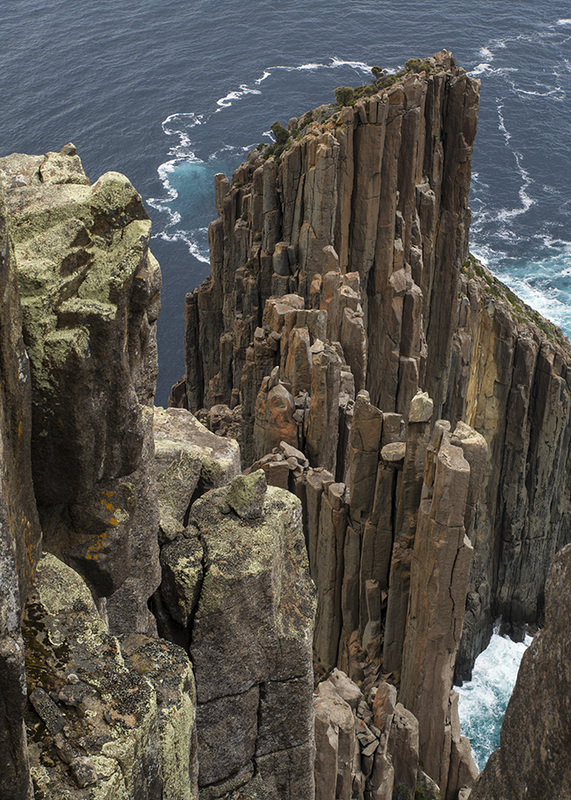
Once we had finished lunch, we retraced our steps back to the main track and followed it on for another twenty minutes to where it terminated right at the rocky photogenic tip of Cape Raoul.
Unlike the bland, unchanging rock Nickelback have been pumping out for years, the structure of the rocks here was amazing- a seemingly random and delicate arrangement of uneven pillars that dropped sharply away to the sea.
Looking out from the cape we saw the first signs that the weather was changing.The sky above us was still clear, but far in the distance you could see cloud thickening.You could also see a few patches of darkness over the water from approaching squalls. Despite this, we didn’t rush to get out of there. Many photographs were taken and I clambered around bit wondering if there was a climbing route down to the bottom (for the record there isn’t unless you are Spiderman). Eventually we took our last look over the spectacular scenery and turned back to head home.
The wind whipped up quicker than people forgot the name Zain Malik, but the walk back was still pretty comfortable.The thick foliage provided surprisingly effective shelter for a lot of the way. There was a reasonable amount of climbing too, so I was quite warm and often thankful for the breaks in the shelter so I could let the wind cool me down once in a while.
As we neared the end of the walk, the clouds and rain began to close in and it was fast becoming murkier than the moral justification for Australia’s border protection policies. There was a light sprinkle of precipitation as we got into the car, but we had only been driving for five minutes before the rain struck properly.
